
Charlie Loyd @vruba@everything.happens.horse
- charlie@planet.parts
- work
- geographical pixels
- where
- Xučyun/Oakland, Ohlone land, western Laurentian accretions
- who
- him
You know him on the internet. Eucalypt-adjacent; very occasional writer. Consulting and passively looking for work in geospatial, image processing, and related fields.
Joined Apr 2022
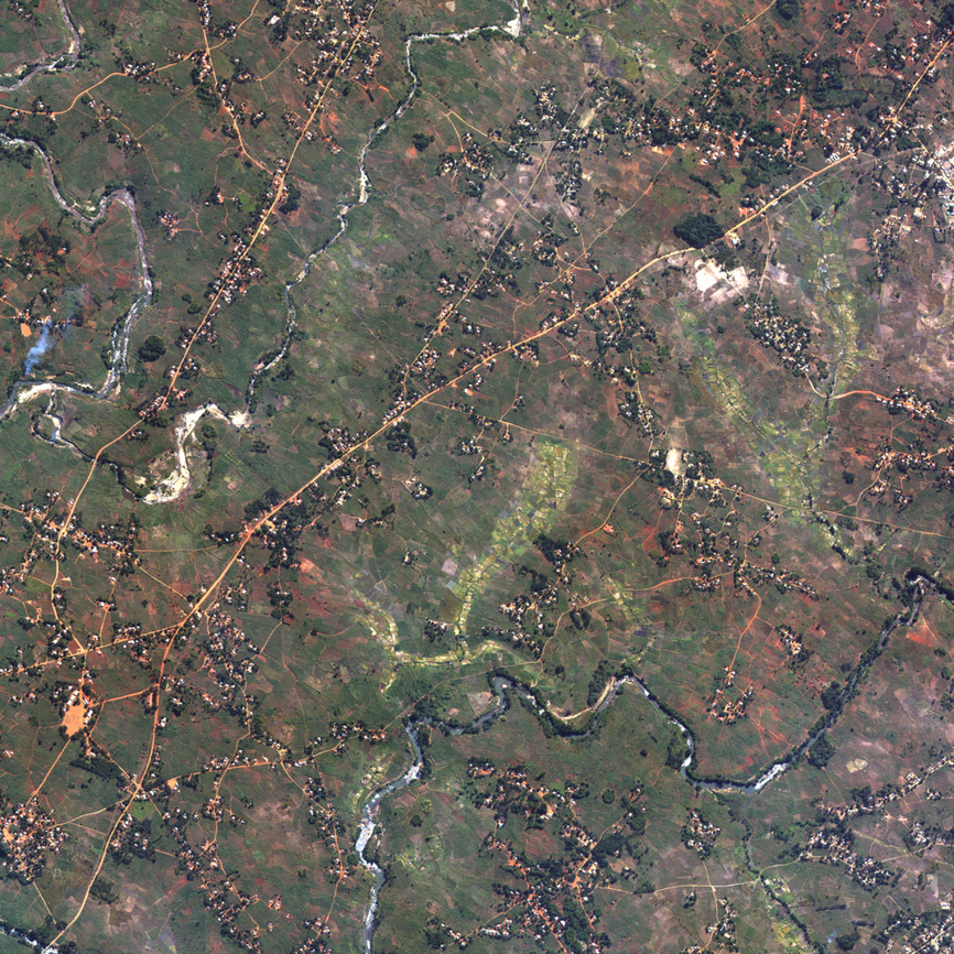
Messing with sliced optimal transport cartograms again.
Charlie Loyd
boosted
Reflecting once again on how much more pleasant and illuminating online discourse would be if people simply put aside their self-regard and took the time – before commenting on anything – to sit down and learn to see everything exactly as I do.
Charlie Loyd
boosted
[Looking at a society where decision-making power is strongly inversely correlated with exposure to the consequences of one’s decisions:] Now hang on, why are there so many bad decisions?
Charlie Loyd
boosted
A little unexpected good news: I spent 90 seconds looking into the thing in the news and it turns out it’s actually really good evidence of the veracity of an opinion I already had.
Charlie Loyd
boosted

I'm nearing the end of a two-month residency at MakerLabs, a community fabrication space here in East Vancouver. I'll write and share more about it online soon, but if you're in the Lower Mainland, please come out this Wednesday, February 25th from 7-8:30pm to see what I've been up to, along with the rest of the cohort!
Link + RSVP: https://www.eventbrite.ca/e/tools-for-change-showcase-meetup-tickets-1974947151093
Charlie Loyd
boosted

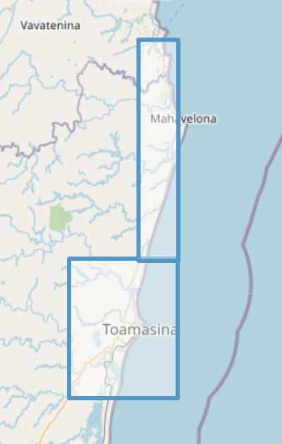
NEW Vantor Open Data for Cyclone Gezani impacts in Madagascar
@Tim_Eagon @marimo The ones I’ve watched so far seem to understand the genre fiction spirit of the originals better than most adaptations do, and have some very enjoyable touches. If I wanted to pick them apart, I could, but I don’t want to.
Allow me to recommend the Soviet production of Sherlock Holmes on YouTube. As an index of its vibe, this is how it depicts a man who has just arrived from Canada.
food (veg)
@brennen What’s the vegetarian protein of choice?
I am still a novice at Rust but it’s hard to emphasize enough how non-annoying it is in general.
I’m not a big PL nerd, but rarely do I think “oh, the people who put this together actually thought carefully about it” – Scheme, Postscript, HyperCard, Haskell maybe (I don’t know it well enough), and precious few others.
Rust feels like a low-level language designed by people who understand and sincerely appreciate current-millennium high-level languages instead of feeling insecure about them.
@urschrei I feel like one of my only semi-useful skills in geospatial is having some slight intuition around what’s going to be fast or not, and now I guess I just don’t.
@ceejbot And rob myself of the joy of writing a custom sorting function and yelling at people who don’t use it? Don’t be naïve.
Charlie Loyd
boosted

The documentation for this image processing library is one of the most interesting things I've read in weeks:
https://github.com/celoyd/potato/blob/main/docs/personal.md
https://github.com/celoyd/potato/blob/main/README.md
https://github.com/celoyd/potato/blob/main/docs/concepts.md
Philosophical discussion of the nature of seeing and what am image is vs a map, fascinating technical details about how satellite imaging works and why it looks as bad as it often does, a lot of really thoughtful conversation about engineering and aesthetic process, and even an amusing unit of measurement — grams per terrapixel.
@nasser Also one named Hemnry V.
@kyle I really appreciate that. I wrote the kind of thing I would want to read, is the short version. And although I spent a reasonable number of hours on it, I think the secret is really that it was slow – the hours were spread over years. Unfortunately I think the organization suffers from my lack of outsider perspective.
- charlie@planet.parts
- work
- geographical pixels
- where
- Xučyun/Oakland, Ohlone land, western Laurentian accretions
- who
- him
You know him on the internet. Eucalypt-adjacent; very occasional writer. Consulting and passively looking for work in geospatial, image processing, and related fields.
Joined Apr 2022
